The Pennar Gorge & Gandikota Fort
Introduction
Tucked away in the remoteness of the Telugu-hinterland, lies a
sight that has the potential to humble man before the glory and raw
power of the natural order. The river Pennar (also Penna, Penneru), originating near the Nandi Hills in Karnataka, winds its way first north
and then east towards the Bay of Bengal and carves out a gorge as it
passes the Erramala hills of central Andhra Pradesh. The southern wall of
the gorge was the site of the medieval fortress of Gandikota -
literally a fort (kote) on a gorge (gandi).


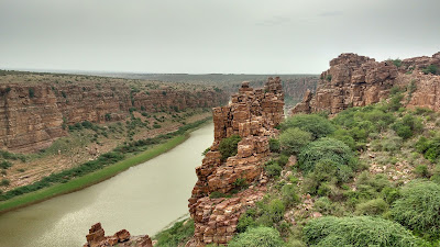
The Gorge of the Pennar at Gandikota
Gandikota, today, is a remote place with spartan infrastructure and
spotty connectivity. Nevertheless,
this is a place which has to be visited, if not for the history, then only to be humbled by the
power of nature to shape our lives.
-x-x-x-
The Gandikota Fort
The Gandkota fort originated as a simple fortification on the
southern side of the gorge in the eleventh century, at a site identified
for having excellent natural defences. The fort in its present state
was upgraded by the Pemmasani Naidu feudatories of the Vijayanagara
Empire (Hampi) during the fourteenth century. The fort passed through
several dynasties and empires like the Golconda Sultans, Marathas, Tipu
Sultan and eventually ending with the British who dismantled the
armaments.


Entering the fort

The main gate of the fort
The fort is almost squarish in structure with 101 bastions. The main entrance is on
the eastern side. the eastern, western and southern walls are at a level
for most of the part. The northern wall follows the topography of the
southern wall of the gorge - from a high of almost 400 feet above the
river to a low of about a 100 odd feet. This northern wall is a perfect
place to see the gorge and the river. The Pennar here has water almost
through the year owing to two dams - one upstream and one downstream
from the gorge.


Watch towers next to the gate

The archway that leads to the inside of the fort

The fort jail
The fort has several structures of note which are covered separately.
-x-x-x-
The Charminar
It is said in Hyderabad that all roads lead to the Charminar. The
same is technically correct for the Gandikota Charminar as well, since
the only road from the fort gate passes next to the Charminar before
branching off to toher sites. Also, let the name not fool you here -
this Charminar is merely a single square structure, rather than one with
four towers. The monument is also the site of the small settlement
which has been inside Gandikota for generations now.


The Charminar of Gandikota
-x-x-x-
Madhavraya Swami Gudi
The majestic gopuram (entrance tower) of the Madhavraya Swami
Temple is visible far before one arrives at the actual fort walls. The
temple is approached from a path south of the Charminar, that passes
adjacent to a dilapidated tank.


The majestic Gopurum - with human for scale

The Gopuram - up close

The gatekeepers of the temple

A troop of langurs having a good time

The Madhavaraya Swami Temple Complex

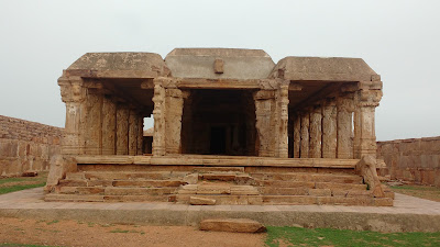
The outer hall of the temple - Sabhamandapa

The inner hall of the temple - Mukhamandapa
-x-x-x-
The Granary and Jumma Masjid
The Jumma Masjid and the Granary are located in a single complex
west of the Charminar, next to a stepped tank labelled simply as the 'Big Tank'.
The granary is supposed to have a vaulted roof, while the mosque is
known for its intricacy. This complex was locked at the time of my
visit, so I could not see how it actually looks form the inside.


The granary of the fort

the facade of the Jumma Masjid

The 'big' stepped tank
-x-x-x-
Ranganatha Alayam
This temple is located to the north of the mosque and granary
complex on an elevated hillock of sorts. The inner structure has similar motifs
to the Madhavaraya Swami Temple, but comparatively less ornate. The outer walls give a panoramic view
of the entire fort.


The Ranganath Alayam

The insides of the complex

The outer hall - Sabhamandapa
-x-x-x-
The Pennar Viewpoint
This is the calling card for Gandikota - the Pennar Gorge. The path
from Ranganatha Alayam continues northward to the gorge. The last part
of the trail to the gorge involves hopping on the boulders that comprise
the landscape. This is the highest point of the gorge - the greenish
river flows silently below. Westward from this point, the wall slopes
down to almost meet the river. There are bastions there and it is
possible to descend all the way down.


Approaching the Pennar
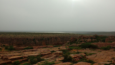
The backwaters of the downstream dam can be seen in the background

The Pennar Gorge and the fort walls

Looking down where the walls almost meet the Pennar

A herd of buffaloes crossing the Pennar (black trails)
-x-x-x-
Getting In and Around
The nearest town to Gandikota is Jammalmadugu, about 10kms away.
The town has limited tourist infrastructure with a couple of lodges.
APSRTC connects Jammalmadugu to Bengaluru and Hyderabad. There are three
buses through the day that go to Gandikota, with the first bus leaving
at 5:30am. Rickshaws are available as an alternative.
Gandikota on the map
APTDC has a resort of sorts next to the Gandikota fort. The resort
itself is fashioned to look like a fort. Reservations are strictly
online, with spot bookings not being entertained. They serve breakfast after 7am.
-x-x-x-
Signing Off
Gandkota is a rewarding place. The endless vista of the Erramala,
punctuated by the green river below, with occasional cattle crossings
paint a beautiful canvas - a canvas in which one may feel
inconsequential at best, or even timid to realize what minuscule power
one holds over the might of nature. It's a little off track, but surely
worth a visit.
Also, one may head to Belum caves and/or Tadipatri for some more beautiful but offbeat places.
-x-x-x-
© KP On The Go!
An attractive and historical place !! Thanks for the information
ReplyDelete