Posts

Showing posts with the label HIKES

Tungnath And Chandrashila - An Easy Himalayan Trek

Image
Introduction The temple of Lord Tungnath in Uttarakhand - at an elevation of about 3200m above sea level - is supposed to be the highest Shiva temple in the world. The temple is accessed after a hike of about 3km from the road-head at Chopta. The temple is one among the revered Panch-Kedar shrines and sees a steady flow of devotees. The summit of Chandrashila lies about 1km ahead and above the temple of Tungnath. At an elevation of 4000m, Chandrashila acts like an elevated platform of sorts with a majestic - almost 360 degree - view of the Himalayan peaks. The sunrise at Chandrashila -x-x-x- A Small Challenge A quick tip - always backup your photos as soon as possible. I lost mine - quite a few lovely ones from the trek included - when my phone went dead all of a sudden. Only two - the ones uploaded on Instagram - survived. The loss of pics means that the post will have to be described in detail without any visual cues , i.e. a wall of text. I hope you all bear with me...
Mandu - Arches Of The Malwa Sultanate

Image
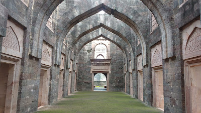
Introduction Mandu - or Mandavgarh or Mandav - is described as a place lost in time. The old fortress of Mandav is perched at the southern edge of Malwa, overlooking the Narmada. It assumed importance in the 13th century when the Parmara kings of Dhar shifted their capital here due to its elevation and strategic natural defences. Mandav saw its glory days in the 15th-16th centuries under the Khilji Dynasty - an offshoot of the Delhi Sultanate. Subsequent power struggles saw the gradual decline of Mandav. The 18th century gave the last fatal blow to the town when the Marathas shifted the capital of Malwa back to Dhar. The arches of the Hindola Mahal in Mandav Almost three centuries later, the old town still reminds people of its glory in the magnificent monuments that have remarkably stood the test of time - with their timeless arches and design synergy between the earth, the light and the water. -x-x-x- Getting In And Around The primary access for Mandav is through Ind...

The Pennar Gorge & Gandikota Fort

Image
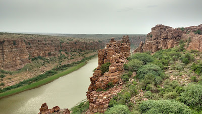
Introduction Tucked away in the remoteness of the Telugu-hinterland, lies a sight that has the potential to humble man before the glory and raw power of the natural order. The river Pennar (also Penna, Penneru), originating near the Nandi Hills in Karnataka, winds its way first north and then east towards the Bay of Bengal and carves out a gorge as it passes the Erramala hills of central Andhra Pradesh. The southern wall of the gorge was the site of the medieval fortress of Gandikota - literally a fort ( kote ) on a gorge ( gandi ).   The Gorge of the Pennar at Gandikota Gandikota, today, is a remote place with spartan infrastructure and spotty connectivity. Nevertheless, this is a place which has to be visited, if not for the history, then only to be humbled by the power of nature to shape our lives. -x-x-x- The Gandikota Fort The Gandkota fort originated as a simple fortification on the southern side of the gorge in the eleventh century, at...